Warsaw, block by block
Warsaw is the only European capital where roughly 85% of the buildings were destroyed in the Second World War. The Old Town was rebuilt between 1945 and 1953 from Bernardo Bellotto's 18th-century paintings and survivor sketches; UNESCO inscribed the reconstruction itself in 1980, citing the act of rebuilding as the world-heritage value. The right bank of the Wisła survived nearly intact because the Red Army stopped at the river on 14 September 1944, before they could cross. The city went from about 1.3 million people in 1939 to roughly 162,000 by the end of 1944.
About 1.86 million live here now, closer to 2 million counting the unregistered. After 24 February 2022 Warsaw absorbed the largest single Ukrainian refugee population in Europe; effective population grew 15% in the first months. Average flat price hit 18,550 PLN per square metre in April 2026. The destruction sits differently in each district. Four of them, picked for contrast.
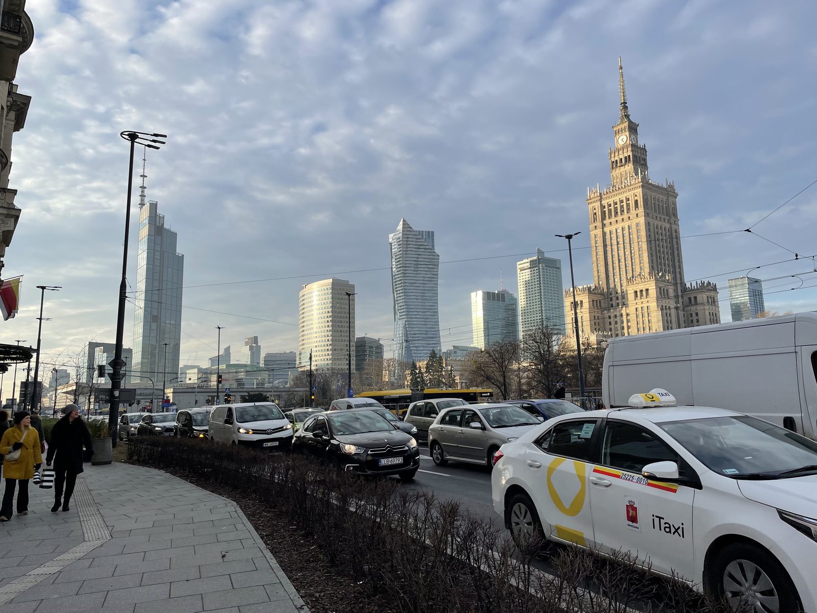
Śródmieście
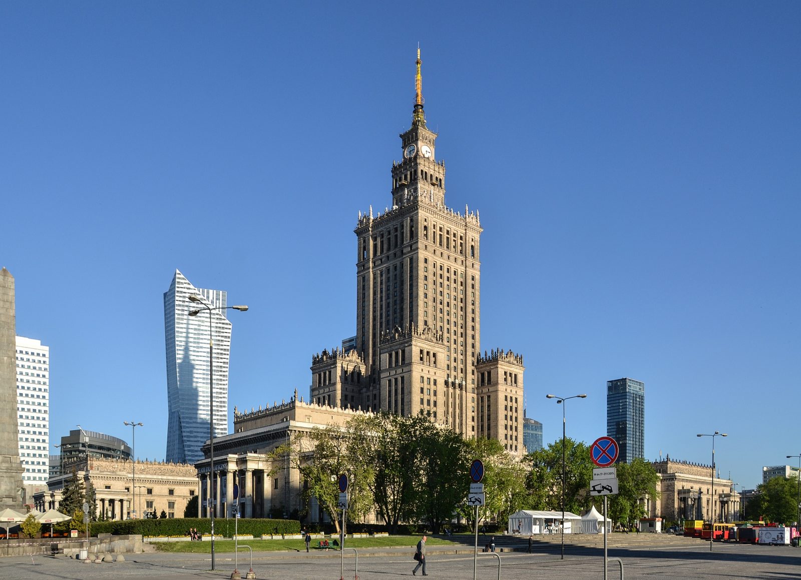
Photo: Pudelek (Marcin Szala) / Wikimedia Commons (CC BY-SA 4.0)
Most of what you photograph in Warsaw's centre is younger than Paris's metro and pretends to be older than the United States.
The Old Town was 95% rubble in 1945. The reconstruction worked off Bellotto (the nephew of Canaletto, court painter to Stanisław August Poniatowski) and survivor surveys. Walk the Rynek Starego Miasta on a Saturday and you're looking at facades built in the early 1950s pretending to be from the 1640s.
In the middle sits the Pałac Kultury i Nauki, designed by Lev Rudnev and built between 1952 and 1955. 237 metres to the antenna tip, sixteen workers dead on site. Officially a "gift from the Soviet people," locally nicknamed Pekin; Broniewski called it "the nightmare dream of a drunk confectioner." Listed as a Polish historic monument in 2007. The Museum of Modern Art by Thomas Phifer opened on its eastern edge in October 2024.
The milk bars survived. Bar Prasowy at Marszałkowska 10/16 has served pierogi ruskie since 1954. In winter 2011 the city tried to close it; young residents broke in, occupied the place, and served around 200 cheap meals before police arrived. The protests worked and Bar Prasowy reopened under a new tenant.
Bar Bambino on Krucza 21 has been there since the late 1950s, formica tables and the most photographed neon sign in Śródmieście Południowe. Hala Koszyki, the 1908 art-nouveau market hall, reopened in 2016 as Poland's first proper food hall. The Pawilony at Nowy Świat 22/28 became a courtyard of bars in the late 1990s; on Friday and Saturday nights it stays loud until three.
The Pałac Saski reconstruction, announced in 2018, has yet to begin. WXCA won the competition in September 2023, the contract sat in inter-ministerial review for two years, and by early 2026 the site shows only tree clearing and archaeological digs. About 86 million złoty burned since 2021 with no construction. Nobody knows whether the palaces will go up.
Praga Północ
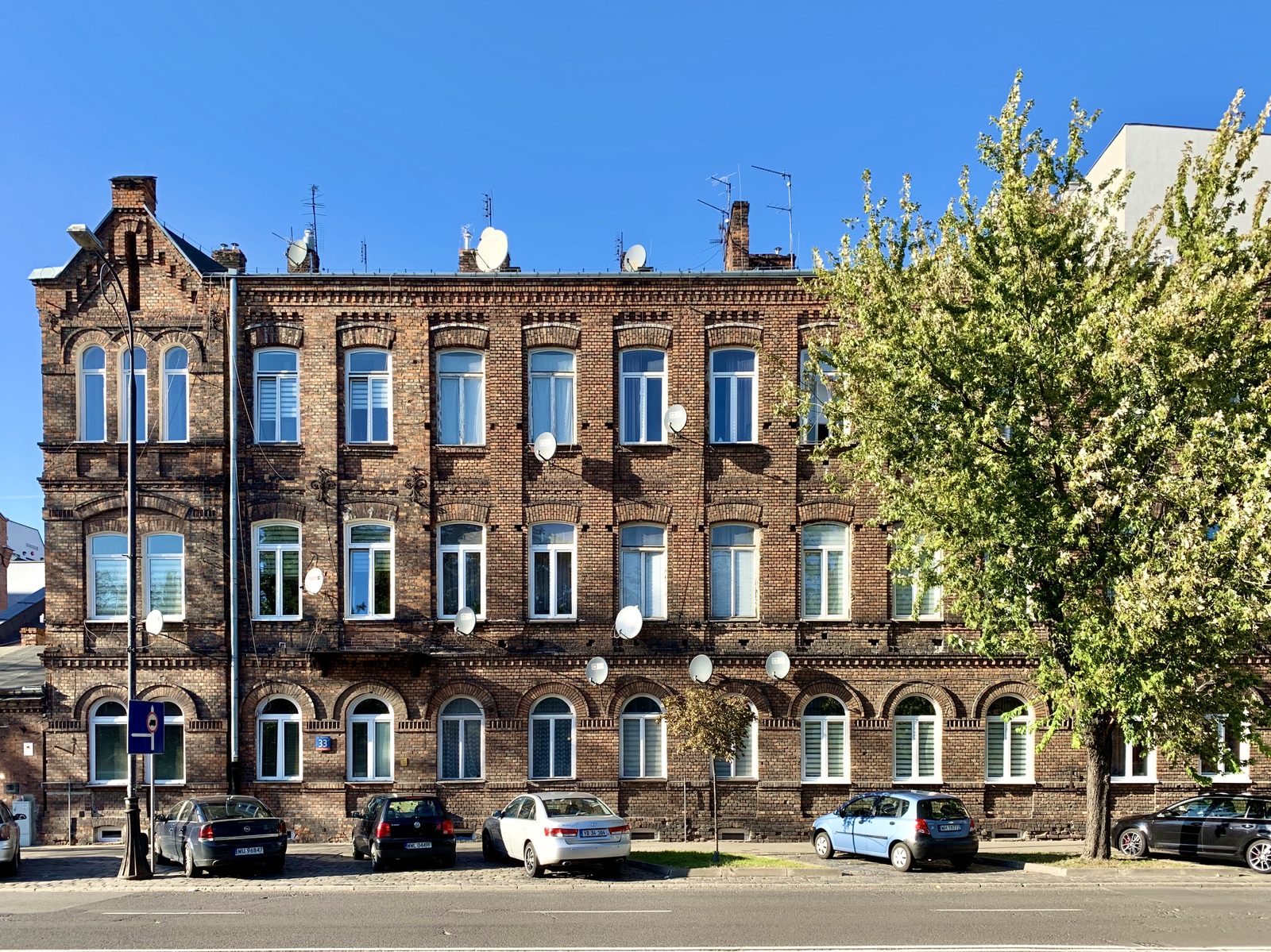
Photo: Chris Olszewski (Kgbo) / Wikimedia Commons (CC BY-SA 4.0)
Praga is the Warsaw that wasn't rebuilt because it didn't need to be.
When the Red Army reached the right bank in September 1944 and stopped there, the Uprising on the left bank was crushed and the centre demolished by the retreating Germans. Praga survived almost intact. The 19th-century brick kamienice on Ząbkowska, Stalowa and Brzeska are not reconstructions from paintings. The actual buildings, with the actual bullet holes, original wooden bramy, original courtyards.
Older layers go further back. Praga got town rights from Władysław IV in 1648 and stayed independent for almost 150 years. On 4 November 1794, Russian troops under Suvorov stormed it during the Kościuszko Insurrection; civilian deaths between 13,000 and 20,000, and Suvorov was promoted to field marshal.
The streets around Targowa and Ząbkowska were roughly 50% Jewish before the war. The circular synagogue at Jagiellońska 28 was destroyed in WWII; two prayer halls survive at Targowa 50/52, now part of the Muzeum Warszawskiej Pragi.
The Centrum Praskie Koneser at Plac Konesera occupies the old Warszawska Wytwórnia Wódek, redeveloped between 2014 and 2018, with the Polish Vodka Museum in the restored 1897 rectification building. Bazar Różyckiego at Targowa 54, founded in 1901 by Julian Różycki, is the oldest market in Warsaw; a fire in March 2025 destroyed about 100 square metres of stalls and the bazar reopened two days later. The Russian Orthodox Sobór św. Marii Magdaleny, built in the 1860s, still anchors Aleja Solidarności. The 11 Listopada 22 courtyard holds three clubs sharing one yard: Hydrozagadka, Skład Butelek, and Chmury.
When metro line M2 reached Dworzec Wileński in March 2015, weekends in Praga changed. Prices in Praga Północ averaged 14,500-18,000 złoty per square metre across 2025, cheaper than Śródmieście at 28,000-30,000. The gap is closing.
A resident quoted in Raport Warszawski about being moved out for tenement renovation: "Ja myślałem, że może jak wyremontują budynek to dadzą mi wrócić. Pytałem administrację, gdy do mnie przyszli i powiedzieli mi, że nie ma opcji powrotu, że już tu się wyprowadzamy na stałe." The "real Warsaw" framing is true at the level of building stock.
Powiśle
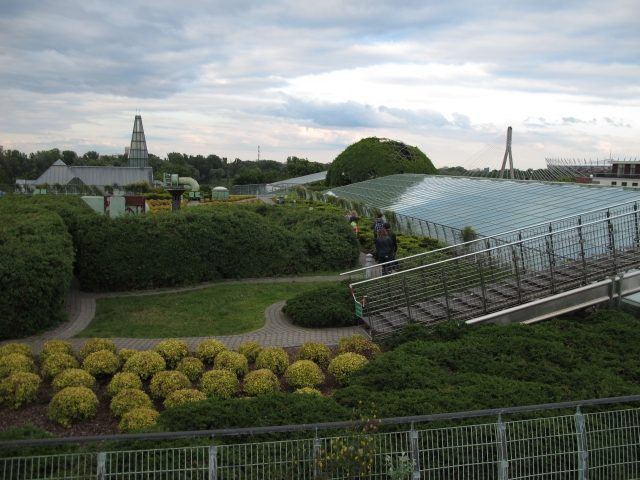
Photo: Ratoncito Perez / Wikimedia Commons (CC0)
The Wisła was Warsaw's back, not its face, until about 2010.
Powiśle is the narrow strip wedged between the steep skarpa escarpment and the river. The city put its sugar refineries, slaughterhouses, sewage works and the Elektrownia here. It flooded regularly and the bourgeois city up on the bluff didn't look down. In September 1944 the Germans took Powiśle after fierce fighting around the Elektrownia (which had powered the Uprising) and most of the district was destroyed.
The reversal started with BUW at Dobra 56/66, opened in December 1999 to a design by Marek Budzyński and Zbigniew Badowski. The copper-green facade carries massive tablets in Latin, Sanskrit, Old Polish and Arabic. The rooftop garden by Irena Bajerska, opened two and a half years later, covers more than a hectare and is among the largest in Europe.
Most Świętokrzyski, the country's first cable-stayed bridge, opened a year after BUW and made the riverbank legible. Centrum Nauki Kopernik followed in 2010 with EU co-financing; the Bulwary Wiślane were laid down in stages between 2015 and 2017. The Elektrownia itself sat empty for two decades and reopened in May 2020 as a mixed-use complex on roughly 90,000 square metres. Across the river, Plaża Poniatówka runs a free Pliszka ferry back to the left bank.
The Pomnik Syrenki at Wybrzeże Kościuszkowskie was unveiled in April 1939, the last monument put up before the war. Ludwika Nitschowa sculpted it; the poet Krystyna Krahelska, then 23, modelled the face and was killed in the 1944 Uprising. Powiśle now averages about 21,700 złoty per square metre. Time Out put it sixth on its global Coolest Neighbourhoods list in 2020.
Wola
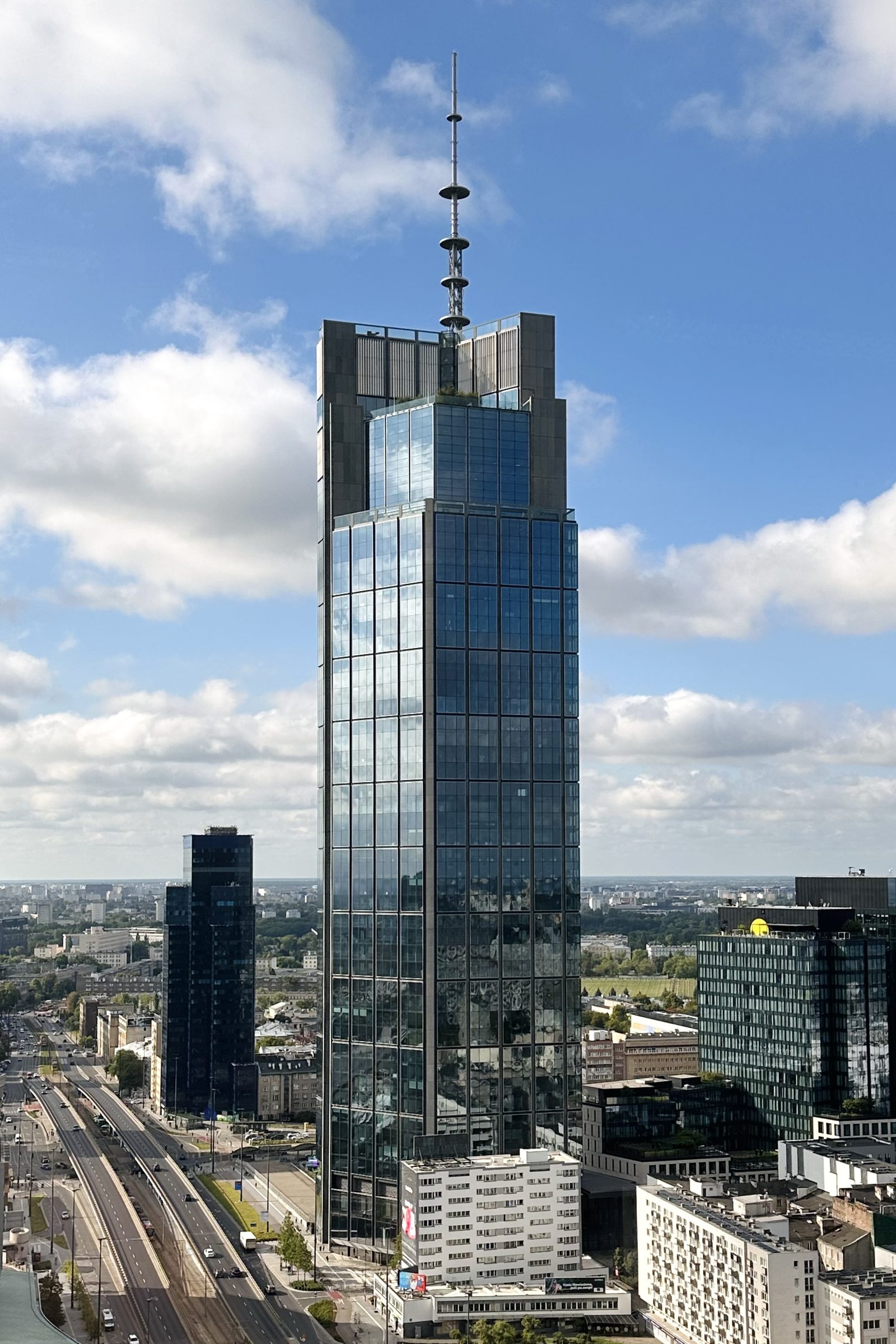
Photo: Daeheung / Wikimedia Commons (CC0)
Wola is the contrast that defines modern Warsaw.
Governor Ludwig Fischer ordered the Warsaw Ghetto created in October 1940; the perimeter walls were finished and the ghetto sealed six weeks later. Around 400,000 Jews were forced into roughly 3.4 square kilometres at peak, the densest urban concentration of any ghetto in occupied Europe. Famine and typhus killed tens of thousands before the deportations started. Over two months in summer 1942, about 254,000 to 265,000 Jews were deported from the Umschlagplatz to Treblinka.
The Ghetto Uprising ran from 19 April to 16 May 1943 under Mordechaj Anielewicz, who died at the bunker at ulica Miła 18. Around 13,000 Jews were killed in the fighting and the burning of the ghetto by SS-Brigadeführer Jürgen Stroop.
A separate event, often confused with it, came the following year. Over five days in early August 1944 German units (including the Dirlewanger and Kaminski brigades) carried out the Wola Massacre. Estimates range from 30,000 to 65,000 Polish civilians killed, most historians settle between 40,000 and 50,000. The 5th of August is often called the bloodiest day of the war for Polish civilians.
Today the same district has the tallest building in the European Union. Varso Tower at Chmielna 73, designed by Foster + Partners and developed by HB Reavis, opened to tenants in February 2022. 310 metres to the spire, 230 to the roof. Warsaw Spire on Plac Europejski, completed in 2016, hits 220 metres.
Around them: Google Poland's Warsaw Hub (the largest Google office in the EU at opening), Microsoft, mBank, Mastercard, Warner Bros. Discovery, Allegro. Rondo Daszyńskiego is now Warsaw's primary office submarket, ahead of Mokotów. Apartments in Wola in 2024 ran 15,000 to 22,000 złoty per square metre.
The memory is woven through it. The Powstanie Warszawskie Museum at Grzybowska 79 opened on the 60th anniversary of the Uprising, in a former tram power station. The POLIN Museum opened a decade later inside the former ghetto, designed by Lahdelma & Mahlamäki, and won European Museum of the Year 2016. It sits opposite the Ghetto Heroes Monument by Nathan Rapoport, where Willy Brandt knelt in 1970.
The Cmentarz Żydowski on Okopowa, founded in 1806, is the largest active Jewish cemetery in Europe, with about 250,000 marked graves and unmarked thousands more from the ghetto mass burials. The cobblestones at Chłodna and Żelazna mark the line of the wooden footbridge that connected the small and large ghettos; a small memorial and a photograph are mounted at the spot.
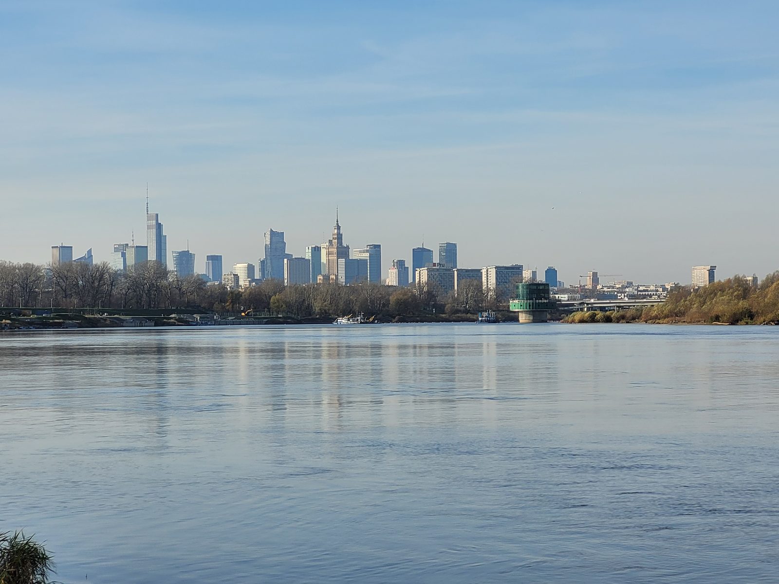
Photo: Wistula / Wikimedia Commons (CC BY-SA 4.0)
In 80 years Warsaw went from almost entirely gone to building the tallest tower in the European Union on the same district where tens of thousands of civilians were murdered in five days. The city is fully aware of this and the museums sit inside the towers.
See the full Warsaw neighborhood scores or explore the map. Data from OpenStreetMap.